
Dr Greg Vasilopoulos and the IMMERSE Project Team, Energy and Environment Institute, University of Hull
Walking on the coast between Paull and Sunk Island, if you look south across the water towards the horizon you might be able to distinguish Grimsby’s river terminal on Humber’s south bank. This is where researchers from the University of Hull have installed a SeaPRISM photometer. An instrument that regularly measures the colour of water in the outer estuary and is member of the AERONET OC initiative.
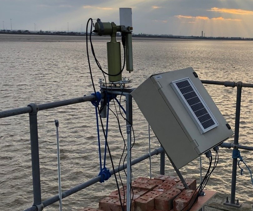
Figure 1: SeaPRISM photometer installed at the Grimsby River Terminal. Photo credit: Rodney Forster
Like many other estuaries, the Humber is very rich in sediment and nutrients. Previous work has shown that the sediments found in the Humber have their source in the North Sea and the eroding cliffs of the Holderness coast, while the Ouse and Trent rivers that flow into the estuary contribute only modestly. On the other hand, the Ouse and Trent contribute a considerable amount of nutrients (Nitrogen and Phosphorus) into the Humber. This is important because excess nutrients in estuaries can increase primary production driving eutrophication, algae blooms and hypoxia that can harm sensitive ecosystems.
Although the Humber is hypernutrified, it is also very turbid and the latter acts to limit available light which in turn controls primary production and eutrophication (Boyes and Elliot, 2006). In fact, a significant ‘Turbidity Maximum Zone’ exists in the Humber which, as its name suggest, is a region where sediment concentrations in the water column are particularly high. This Turbidity Maximum Zone (or TMZ for short) is formed at the interface of river and sea water, and its location, extent and intensity vary in time. Periods characterised by low river flow and high tides are associated with a migration of the TMZ upstream. Conversely, when river flow is very high (for example during intense rainfall events) the TMZ is pushed seaward and in some occasions even get flushed out of an estuary (Pritchard and Green, 2017).
The highly dynamic relationship between the TMZ, river flow conditions and tide levels suggest that Humber’s TMZ might be different in the future. This is because of rising sea levels and changes in rainfall patterns due to projected climate change. Future changes of the TMZ can have knock-on effects on the sensitive interplay between sediment and nutrients in the estuary. This in turn may affect habitats for marine and intertidal organisms.
As part of the EU Interreg-funded IMMERSE project, a team of scientists at the University of Hull are monitoring the Humber to measure the amount of sediment and nutrients within the estuary and how it evolves in time due to changes of river flow and tidal forcing.
Two complementary methods are used to monitor the dynamics of the TMZ in the Humber. Water samples are collected from three sites, using automated systems (Figure 2), on the Rivers Ouse, Trent and the Humber in Grimsby. These samples are then transferred in our laboratories at the University of Hull where they are analysed to measure the concentration of nutrients such as Nitrogen and Phosphorus, salinity, turbidity and chlorophyll content. In the next step, these samples are filtered, dried and weighted using specialised laboratory equipment to quantify the amount of suspended sediment for each sample (Figure 2).
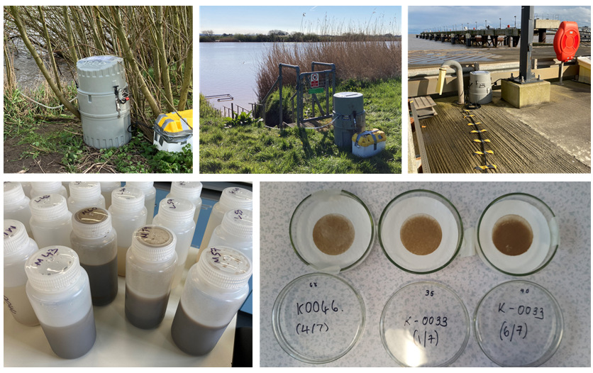
Figure 2: Autosamplers installed at the banks of the rivers Ouse and Trent and at the Grimsby river terminal (top) samples brought back in the laboratory (bottom left) are processed to extract their sediment content (bottom right). Photo credit: Hannah Chambers, Greg Vasilopoulos.
The second method relies on publicly available satellite products from the European Space Agency’s Sentinel-2 mission. Sentinel-2 satellites orbit the Earth regularly capturing an image of the Humber every five days, using multispectral sensors. Changes of the turbidity and chlorophyll content within the estuary are shown in the reflected water colour captured in the satellite images (Figure 3). This enables us to look back into the Sentinel-2 archive and try and understand how the TMZ changed in the recent past, seasonally or due to extreme weather events.
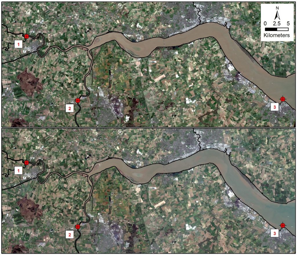
Figure 3: The Humber estuary captured by the European Space Agency satellite Sentinel-2 on 04 April 2021 (top) and 19 April 2021 (bottom). Changes of water colour at the outer estuary indicate a difference of suspended sediment concentration in the water column between the two captures. Numbered points indicate locations of water sample collection. Source: https://scihub.copernicus.eu/
However, the Earth’s atmosphere between the Humber and the Sentinel-2 satellites (that fly 786 kilometres above the estuary) causes a considerable interference in the captured images. Therefore, satellite images, captured from space, require ‘ground truthing’ against similar observations captured on the Earth’s surface. Comparing water reflectance measured at Grimsby by the SeaPRISM photometer (that we saw at the start of this post) and from space by Sentinel-2 allow us to calibrate the Sentinel-2 products.
Comparing our laboratory measurements with satellite data will enable us to better understand sediment and nutrient dynamics in the Humber estuary and project them into the future. This will be valuable to identify future threats to the Humber’s ecosystem habitats and also to inform numerical models developed as part of IMMERSE and discussed in a previous blog entry from my colleague Dr Rob Thomas.
If you would like to to learn more about my work, see my staff page, LinkedIn, follow me on twitter @gregvasilop or email me