
Dr Rob Thomas and the IMMERSE Project Team, Energy and Environment Institute, University of Hull
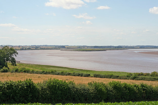
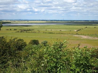
Walking eastwards from Trent Falls and Wallingfen – which my colleague Prof. Briony McDonagh talked about last week – the wide expanse of the Humber Estuary will be on your right-hand side.
The Humber drains one fifth of England (24,472 km2), and provides the largest single input of freshwater to the North Sea from the English coastline. The Humber and its surrounds house 500,000 people, 120,000 ha of agricultural land, the second largest chemical cluster in the UK, two of the country’s six oil refineries, and five power stations. More than 25% of the UK’s primary energy supply flows through the region, and its ports handle 14% of UK trade.
The estuary also provides extensive wildlife habitat in its large intertidal zones and salt marshes. As a result, it has been given a number of nature conservation designations under UK, European, and international law. It is a Natura 2000 site, a Special Area of Conservation (SAC), a Special Protection Area (SPA), and a Ramsar site, together forming the Humber Estuary European Marine Site.
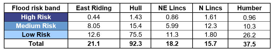
However, the Humber is also the second most flood-prone region in the UK after London, with over 190,000 or over one third of properties at risk (see Table). In Hull, this rises to over 90% of properties (see Table). This risk is expected to be exacerbated by future sea level rise, which is predicted to be between 0.26 – 1.45 m by 2100 (Lowe et al. 2018). In 2008, the Environment Agency (EA) published its Humber Flood Risk Management Strategy, which aimed to provide adequate protection against tidal flooding until 2033. Following the 2013 storm surge, the EA reviewed this strategy, leading to the “Humber 2100+” project to look at longer-term, systems-based solutions for water management.
Percentage of Humber properties at risk of river and/or coastal flooding (Environment Agency, 2020). The flood risk bands are defined as:
High: more than a 3.3% chance (1 in 30);
Medium: less than a 3.3% chance but more than a 1% chance (1 in 100); and
Low: less than a 1% chance but more than a 0.1% chance (1 in 1,000).
Humber 2100+ is being co-developed with partners – the 12 local authorities that have estuary shorelines – and key stakeholders including Associated British Ports, Catch, the National Farmers Union, Natural England and Internal Drainage Boards, to provide cost effective, longer-term resilience against tidal flooding while supporting the health and wellbeing of communities, the environment, and sustainable economic growth. Potential approaches range from local resilience improvements and “Living with Water” to a large-scale Thames-style barrier.
As part of the EU Interreg-funded IMMERSE project, a team of scientists at the University of Hull have used our CAESAR-Lisflood computer model to study the potential effectiveness of various flood risk management options (see maps below). We have focused particularly on so-called managed realignment schemes. These typically build new embankments landward of existing defences and allow preferential flooding of transitional grasslands adjacent to the estuary. The flooded land can serve a dual purpose:
- It creates habitat to help offset losses caused by development and coastal squeeze elsewhere on the estuary. Over time, transitional grasslands are expected to morph into saltmarshes, reedbeds and eventually intertidal mudflats; and
- Overspilling water reduces the amount of water in-channel and reduces wide area flood risk.
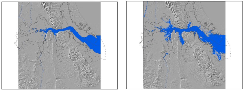
Figure above: Simulated flood extents for present-day flood defences in the Humber during the 1 in 200 year storm surge event of 5th December 2013 and present-day sea levels (left) and with sea level rise of 1 m, approximating the forecast sea level rise to the year 2100 (right)
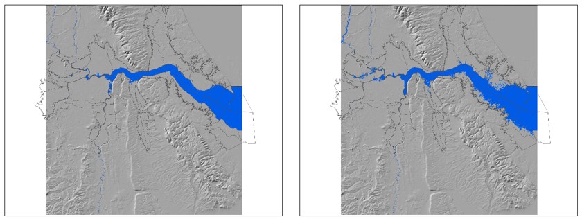
Figure above: Simulated flood extents for present-day flood defences raised by 1 m and supplemented with managed realignment sites throughout the Humber estuary for the 1 in 200 year storm surge event of 5th December 2013 and present-day sea levels (left) and with sea level rise of 1 m, approximating the forecast sea level rise to the year 2100 (right)
Our results show that managed realignment schemes in the middle-to-inner estuary, for example at Alkborough on the South Bank of the Humber near Trent Falls (see photo below), have provided the greatest flood risk benefit.
Simulations of future sea level rise suggest that inner estuary sites will continue to have a flood risk benefit well into the future, while middle-to-outer estuary sites, for example at Paull Holme Strays (see photo below), will provide little flood risk benefit in the future. Conversely, past research by biologists at the University suggests that outer estuary sites have greater benefits for wildlife than inner estuary sites. The Environment Agency are currently assessing the various options.
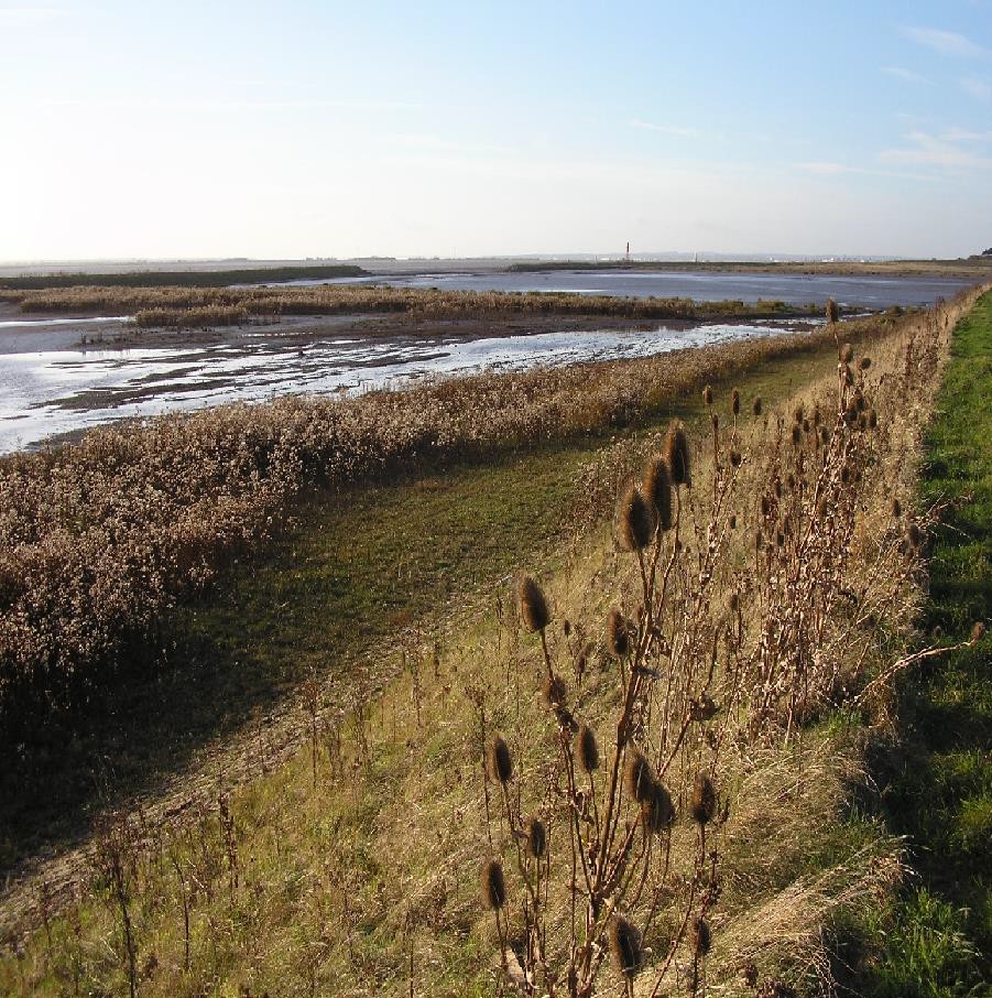
Alkborough flood storage and managed realignment site (left) and Paull Holme Strays managed realignment site (right) (photos from the Environment Agency)
If you wish to learn more about the IMMERSE project or find out more about my work, check out my staff page, find me on LinkedIn or send me an e-mail