
Dr Sam Ramsden, Energy and Environment Institute, University of Hull
Thanks for joining me after your walk so far. As you may know Hull is vulnerable to flooding from a range of sources. The devastating floods of 2007 were caused by heavy rains which overwhelmed the city’s drainage system. Over 20,000 people were affected, 8,800 households were flooded, and over 5,000 households had to evacuate. You can read a report investigating the floods by Professor Tom Coulthard here. In 2013, areas of Hull along the Humber were flooded by a tidal surge. There have also been more localised flooding incidents including in 2014 and the winter of 2019/20 and the risk of flooding is increasing due to the impacts of climate change.
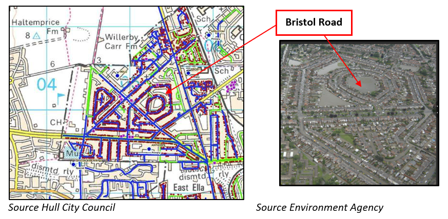
In this blog I am focusing on the impacts of the 2007 floods on Hull, with a focus on an area called Derringham – a suburb in the west of Hull further north from the Humber. I don’t know if you were in Hull at the time? and I am not sure if you know Derringham? Derringham was very badly affected by flooding as shown in the map and picture below. On the map, the blue lines are flooded roads, and the purple dots represent flooded houses and I have highlighted the hexagon shaped Bristol Road.
However, since the floods there has been significant investment in large scale flood defences including along the Humber estuary. More recently, the local Flood Risk Management Agencies (Hull City Council, Yorkshire Water and the Environment Agency, East Riding of Yorkshire Council) have formed the Living with Water partnership which focuses on improving flood protection measures and supporting activities to build community-level flood resilience. The University also supports Living with Water as a key partner. This is a pioneering partnership which should provide learning for similar partnerships in other areas of the UK.
There has also been some inspiring community action. I got involved with the residents of Derringham as part of the Hull Household Survey in 2018 where I worked with Living with Water to set up the survey, identify target areas and feedback the results. In the survey, we asked residents a number of important questions including:
- Were you affected by flooding in 2007 and what were the impacts?
- What do you think about flooding now? Are you concerned about flooding? Have you taken any measures to protect yourselves against flooding? What do you know about the different flood protection schemes being built in Hull?
The results of the survey are shown here.
During the survey work, I met with a community group – the Friends of Garrowby Orchard – at the local Baptist Church who helped disseminate the survey in Derringham. There was a strong sense of community in the area and many people had helped each other during the 2007 floods. Building on this, we got a really good response in Derringham where 169 residents wanted to share their stories and their thoughts about the future.
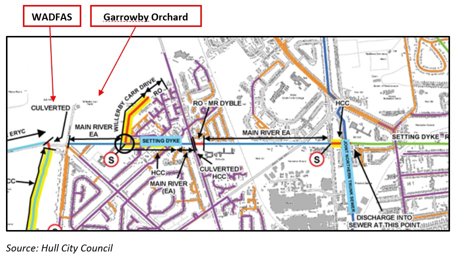
A number of people talked about the importance of historic dykes, drains and ditches to the drainage of the local area. One local resident took me along a walk along Setting Dyke which is one the historic watercourses, draining water into the River Hull. Setting Dyke runs from one of the lagoons of the newly completed Willerby and Derringham Flood Alleviation Scheme (WADFAS) – where Wymersley Road meets Wold Road in Derringham. It is worth checking out the lagoon – it holds water in the event of heavy rains to prevent water flooding the neighbourhood. It is one of the only flood alleviation schemes in Hull and East Riding you can walk alongside and members of the local community checked the water levels there during the heavy rains of the winter of 2019/20 and could see the scheme working.
Here is a map from Hull City Council showing Setting Dyke as part of Hull’s drainage system and I have marked the Willerby and Derringham Flood Alleviation Scheme (WADFAS) and the Orchard.
The area around the orchard was badly flooded in 2007 and an education centre which was on the land has now been abandoned and demolished. Since then, the Friends of Garrowby Orchard (FOGO) has looked after the greenspace, planting native trees, clearing the dyke and hosting a range of community events. To find out more, check out FOGO’s Facebook page which includes details of a community picnic on the Dyke on the 31st of July 2021.
However, one issue that has become evident from other research on flood resilience across Yorkshire is that while there are many examples of inspiring community action, Hull does not have any active long-term flood groups or flood wardens, including in Derringham. This is an area for future activity and the Haltemprice Flood Action Group which operates in neighbouring areas of East Yorkshire could provide an interesting learning example.
Anyway, back to Setting Dyke. After the orchard, the dyke disappears and reappears in various places towards Cottingham where it runs along Snuff Mill-lane along the Cottingham-road to a point near the Gardener’s Arms (which you might know!). It reappears at Ryde Avenue and finally discharges into the river Hull. From there, the water flows southwards down the Hull and out into the Humber near the Deep (the location of one of next week’s blog posts).
More information is available about our Living with Water research in Hull and the East Riding on the University of Hull website. And you can hear more updates about my research and my work with the Risky Cities project by following me on twitter @samramsden2001.